Day trip to Sequoia National Park

April 23rd I headed down the road to explore Sequoia National Park, which is the sister park right next to Kings Canyon National Park. If there were no signs indicating landmarks you would not even know when you are entering and exiting each park, they are sometimes looked as if they are one park.

This view shows one of the world’s largest groves of trees. Redwood Mountain Grove covers 5 square miles of more than 2,100 giant Sequoias trees that are larger than 10 ft in diameter.

Also here is the largest area of wilderness in the lower 48 states covering the span of the Sierra Nevada Mountains that includes both the National Forest and National Parklands.

Further along the General’s Highway through Sequoia National Park, I came across Clover Creek Bridge and Creek which is about a mile from the Wuksachi Lodge turnoff. Clover Creek Bridge is one of two bridges that were constructed in 1930. It is a concrete bridge with a masonry facade, giving it the appearance of a stone bridge which gave it a rustic style appearance that fits in with the surrounding area. There was a small pullout where I was able to park my car and go have a closer look. With it being late April I enjoyed seeing the creek while it was gushing from new snowmelt.

My next stop was the General Sherman Tree Trail. I took this trail which is a mile round trip. At the time I was researching information I found that the shuttle bus does not go to the lower trailhead until summer and I did not know that I could have gotten a handicap pass to put in my car and park in the handicap area because of my bad knees. If I had done that it would have been a much shorter and easier walk…..But I was determined that I wanted to see the General Sherman Tree so I made the hike from the main upper trail that sits at 7000-foot elevation, it is a paved, steep grade path with a few steps and bench seating along the way. There was still snow around and plenty of melting snow runoff.

About 3/4 of the way down you will come to a viewpoint where you can view the General Sherman Tree from a distance. With it being so tall its hard to get a photo when you are closer to it, so you can get a good photo of the whole tree from this spot. There are also benches to sit on and an interpretive sign here that tells you about the General Sherman Tree.

IMG_20190423_140315

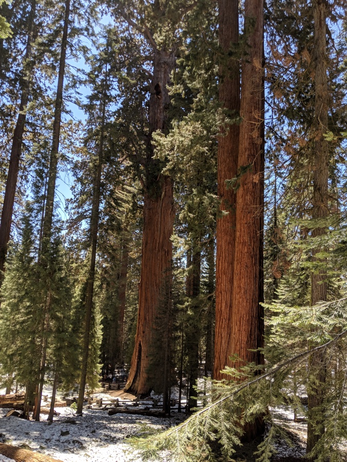
When you finally make your way down to the General Sherman Tree there will be a lot of people lined up to take a photoshoot with the General. There is also a wooden fence around the perimeter of the tree to protect the shallow roots. As you continue walking there is a loop trail where you have the chance to see several other awesome trees, one being the massive fallen Sequoia that the trail goes through, two twin-trees, other Sequoias that have been burned or have interesting growths on them.

General Sherman Tree was named after Civil War General William Tecumseh Sherman…..this trees claim to fame as the biggest tree in the world comes from the volume of its trunk. Some trees are taller, but no other tree has more wood in its trunk. General Sherman stands 275 feet tall and is over 36 ft in diameter at the base. It is believed to be 2,200 years old and weighs about 1,385 tons. The Sherman tree top is dead, so it no longer gets taller, but its trunk keeps increasing. Each year the trunk grows wider, adding enough wood to equal another good-sized tree.

The next stop was the Giant Forest Museum, which to me was not really a museum. Here you are able to talk with rangers about the Sequoias and hiking in the area. It also has a small gift shop and the rest is a display that shares the story of the Giant Forest and Giant Sequoia Trees. The village market building which is listed on the National Register of Historic Places began renovations in 1999 and was converted to a museum and visitors center which was completed in the summer of 2001. The Sentinel which stands directly in front of the Giant Forest Museum is the 13th largest tree in Giant Forest, but the 21st largest in Sequoia National Park.

 On the way back I stopped and took some pictures of the Marble Fork Kaweah River…..So pretty.

And finally here are just some other random nature pictures I saw on my drive


Arrival to Kings Canyon National Park – April 2019

I left Phoenix, AZ on April 6, 2019, to head to Kings Canyon National Park where I would be starting a new job as Cash Auditor for 6 months. I found that my friend Chris, who had been living in California near Visalia for a while was still in the area and was heading out soon so I stopped and spent one night at the KOA near Visalia to see her. I had not seen her in about a year so it was good to catch up.

I pulled out of the KOA April 9th with a forecast of snow expected. I called Kings Canyon to get a more accurate weather report…..I was told it was not snowing at the moment and if it did it proably would not stick around. Well, I did not want to have to contend with snow at all in a 34-foot motorhome towing a car. The drive took me almost an hour going from less than 1,000 ft to 6500 ft at Grant Grove Village and all uphill on a two-lane, winding road. The going was slow…..but I finally made it, checked in and was told I could park my RV at the bottom of the small hill to the staff housing called “Wormwood.” There was still about 2 1/2 feet of snow on the ground and it was going to be a couple weeks before the staff campground would be free of snow. So in the meantime, I would be staying in one of the cabins, which turned out to be more rustic than I anticipated but I knew it would be temporary. I got my key to cabin #10….it was a short walk from the parking area. Most of the walk area was clear of snow except for a few patches. There were some clumps of snow on the cabin steps and I knew once the evening came it was going to ice up, so I asked the maintenance guy if there was a shovel and if we could get the snow off the steps to the cabin. He took care of that for me and I got a few things from my RV and brought to my cabin. The cabin was small with two twin beds and two locker units at the end of the one twin bed for clothes and personal items. One of the locker units had the two nightstands stored in it. I did not feel like dragging them out, so I used the other one that did not have to much stuff in it except for a few odds and ends.  I got a rag and started wiping and cleaning the locker, and swept the floor. The weather was not to bad during the day, but once the sun started going down it got pretty cold. Each cabin had one heater to use because that is all the breakers could handle, otherwise, the breakers would pop, which did eventually happen a few times over the course of the two and a half weeks I ended up being there. The heater helped somewhat, but it was still pretty cold since the cabins were not insulated at all…..they really were not intended for people to stay in during the winter, but there was only so much housing available. We had a common area not far from my cabin that had a kitchen along with two washers and dryers. On each side of the kitchen area outside were the men and women’s bathrooms and showers….. men to the left and women to the right. In the pictures below I have marked my cabin with an “Orange X” and the kitchen and bathroom building with a “Yellow X”

My first day of work was April 12th, so I had a couple days to get acquainted with things and do a little adventuring. My first outing was an eight-mile drive to Hume Lake and General Grant Tree which I have written about in a different blog post.

Hume Lake beginnings go back to the mid to late 19th century. During the 1800s the United States government began selling federal government land to the public. In 1888, two men,  Hiram Smith, and Austin Moore bought thousands of acres of timber for logging the giant redwood trees. They formed the King’s Canyon Lumber Company and began business. After experiencing financial problems, the company was reorganized & renamed the Sanger Lumber Company. By 1905, the Sanger Lumber Company began to decline once again, so the company was sold. Ira Bennett & Thomas Hume then bought the company and land together. Bennette & Hume decided they needed to move the mill operations to be profitable. The mill was moved four miles east to Long Meadow. The water from Long Meadow and Ten Mile Creeks was used to form an artificial body of water, which is now Hume Lake to store & transport the timber. Once again though, the company ran into problems and eventually closed its doors in 1924 because of a lack of profits and a large fire that destroyed over half a million dollars in lumber. The land was sold back to the government and on January 9, 1946, a group of Christian men opened the Hume Lake Christian Camp on 320 acres of lakeshore property.